Aerial Mapping GS-100V UAV LiDAR Scanning System 360 Degree Fov Laser Sensor Colored Point Cloud Free Software
Geosun gAirHawk LiDAR Scanning System GS-100V
gAirHawk GS-100V is a kind of short-range, compact LiDAR point cloud data acquisition system, integrated HESAI XT16 laser scanner, GNSS and IMU positioning and attitude determination system, and storage control unit, is able to real-time, dynamically, massively collect high-precision point cloud data and rich image information. It is widely used in the acquisition of 3D spatial information in surveying, electricity, forestry, agriculture, land planning. GS-100V LiDAR Scanning System Brochure.pdf
Specification of UAV LiDAR Scanning System gAirHawk GS-100V
| UAV LiDAR Scanning System gAirHawk GS-100V | | | Item Name | System Parameters | |
GS-100V
Parameters | Weight | 1.4kg | | Measuring accuracy | Less than 0.1m @100m | | Working temperature | -20℃~55℃ | | Power range | 12V- 24V | | Consumption | 20W | | Carrying Platform | Drone and Vehicle | | Storage | 64GB storage, maximum support 128GB TF card | | Lidar Unit | Measuring Range | 80m@10% Reflectivity, max range 120m | | Laser class | 905nm Class1 (IEC 60825-1:2014) | | Channel | 16-Channel | | Range accuracy | ±1cm (typical Value) | | Scanning frequency | 10HZ, 20HZ | | data | Double echo 640,000 Points/Sec | | FOV | 360°, adjustable | | Laser sensor | HESAI XT16 | | POS Unit | Update frequency | 200HZ | | Heading accuracy | 0.040° | | Pitch accuracy | 0.015° | | Rolling accuracy | 0.015° | | Position accuracy | ≤0.05m | | GNSS signal type | GPSL1/L2/L5 GLONASSL1/L2 BDS B1/B2/B3 GAL E1/E5a/5b | | Pre-processing software | POS software | Output information: position, speed, attitude | | Point cloud software | Output point cloud data format: LAS format, custom TXT format | | Camera (built-in) | Trigger Event | Distance or Time trigger | | Effective Pixel | 26 Mega Pixel & 83 Degree FOV | |
Application of UAV LiDAR Scanning System gAirHawk GS-100V
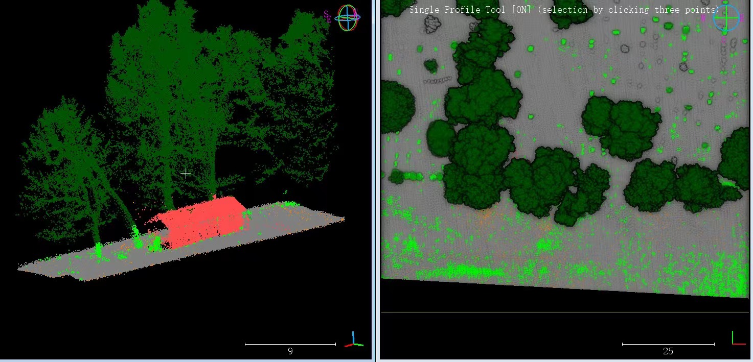
GS-100V LiDAR and GS-850 UAV in the United States, based on high-quality LAS data, using PCA4.2 software for point cloud post-processing, single wood segmentation, point cloud automatic classification, DEM production.


Free Trial Software UAV LiDAR Scanning System gAirHawk GS-100V
Free trial test, achieve high precision
The Guideline of LiDAR Usage and Reference.pdf
Point Cloud Pre-Processing Software Integrated With Trajectory Processing----Geosun Self-developed gAirHawk 5.0
Key Features of gAirHawk 5.0 Software
1. Raw data: intelligently load
2. Four default coordinates
3. Point cloud Optimization
4. Start and stop calculation


Package of UAV LiDAR Scanning System gAirHawk GS-100V
UAV LiDAR Scanning System gAirHawk GS-100V packed by suit case with EVA material liner inside, then covered by hard carton box. It is suitable for air shipment and sea shipment.


Product Tags:

|
|
GS-100V UAV LiDAR System 360 Degree Fov Laser Sensor Colored Point Cloud Free Software Images
|


